Dotted with glaciers, snowy peaks, and pristine wilderness, the vast landscapes of Patagonia are a dream destination for hiking enthusiasts, nature lovers and adventure seekers. While multi-day treks are popular, exploring the region through day hikes offers a unique and accessible way to experience its remote beauty. In this post, we recommend the 17 best day hikes in Patagonia, of varied lengths and difficulty levels – through different national parks in both Argentina and Chile.
This post about day hikes in Patagonia contains affiliate links. We’re not selling anything ourselves – we just help products and services we find great. If you click one of them and decide to purchase, it’ll be at no extra cost to you; and we’ll get a trifle that’ll help us bring you more awesome travel guides.
Jump to:
Patagonia in Argentina
North (3 hikes) | South (6 hikes)
Patagonia in Chile
North (6 hikes) | South (2 hikes)
Hiking in Argentine Patagonia
When you think of hiking in Argentina, you undoubtedly think of Patagonia. Exotic names like Perito Moreno, Cerro Fitz Roy, or Ushuaia, are imbued with an aura of adventure and wild exploration.
These are the most mind-blowing national parks in Patagonia Argentina, from north to south:
- Nahuel Huapi National Park, and the area around Bariloche
- Los Glaciares National Park, with Mount Fitz Roy and Perito Moreno
- Lago del Desierto Provincial Park
- Tierra del Fuego National Park, and the area around Ushuaia
In the sections below, we suggest several stunning day hikes set in the above parks, in varying lengths and difficulty, for an unforgettable hiking holiday in Patagonia, Argentina.
Ready for longer hikes? Check out the best multi-day hikes in Patagonia (Argentina + Chile)

Best day hikes in Patagonia Argentina
Hike from Pampa Linda to Laguna Ilón
📍 Nahuel Huapi National Park
This short, linear hike starts in the town of Pampa Linda, near Bariloche, and ends at Lake Ilón. The ascent at the start is demanding but the view of the snow-capped mountain is definitely worth it.
Alternatively, it’s possible to spend the night in Refugio Ilón, making it a 2-day hike. In that case, leave your backpack there and continue hiking to the stunning Mirada del Doctor. If you keep it as a day hike, just hike back the same trail to Pampa Linda.
Entrance to the park: | 6500 ARS |
| Trail length: | 15 km / 9 mi |
| Difficulty: | Difficult |
| Nearest town: | Bariloche |
| Link to trail: | Alltrails |
| Link to park website: | Nahuel Huapi National Park official website |

Bariloche is the hiking capital of Argentina’s northern Patagonia, located in the Lake District. It’s surrounded by the Nahuel Huapi National Park, a mountainous landscape shaped by glacial activity, creating pristine glacier lakes, numerous rivers, and waterfalls feeding from the glaciers, but also picturesque fjords, bays, and inlets – hence the name “Lake District”.
The rugged terrain showcases a diverse range of ecosystems, from temperate rainforests to alpine meadows and ancient forests, predominantly composed of lenga and coihue trees. These lush, dense forests provide habitat for many wildlife species. Although picturesque, Nahuel Huapi is never crowded, so it’s perfect for those who appreciate some solitude on day hikes.
Hike from Pampa Linda to Refugio Otto Meiling
📍 Nahuel Huapi National Park
This long, linear trek also starts from Pampa Linda, near Bariloche, and ends at the well-known mountain hut Otto Meiling. It’s a popular route in the summer, but it never gets crowded.
The trail is well-marked, ascending continuously on the side of Cerro Tronador through the forest, then on stones. From the top, you can marvel at the best view of the area. As it’s a long hike, many people choose to spend a night in the hut (reservation needed). But if you start early enough or if you’re a fast hiker, it’s possible to complete it within a day.
Entrance to the park: | 6500 ARS |
| Trail length: | 23.2 km / 14.4 mi |
| Difficulty: | Difficult |
| Nearest town: | Bariloche |
| Link to trail: | Alltrails |
| Link to park website: | Nahuel Huapi National Park official website |
Discover more day- and multi-day hikes around Bariloche!
🏅 Our accommodation picks at Bariloche, on Booking.com:
- Stay in this top-rated, beautiful chalet (called cabaña in Spanish) near the Nahuel Huapi trails, in Vila los Coihues – a little village adjacent Bariloche. Its cute wooden decoration is just enchanting!
- Or relax after the hike in this excellent reviewed spa hotel in Bariloche town center. The hotel has an indoor swimming pool as well!
Cerro Campanario hike
📍 Bariloche
Another short hike, right outside of the centre of Bariloche. This one leads to Cerro Campanario, offering a panoramic view of the town and the surrounding lakes, fjords, and inlets.
This continuous steep climb is demanding but not exceedingly busy, as most people choose the chairlift to reach the top. It zigzags among endemic arrayán trees (recognisable with their peeling bark), which provide shade in the summer. The lookout at the peak can be crowded though, depending on the time, and you’ll find a café for refreshments.
Entrance to the park: | free |
| Trail length: | 2.3 km / 1.5 mi |
| Difficulty: | Moderate |
| Nearest town: | Bariloche |
| Link to trail: | Alltrails |
| Link to park website: | Cerro Campanario official website |

Laguna de los Tres hike
📍Los Glaciares National Park
Laguna de los Tres is one of the most sought-after hiking destinations within Los Glaciares National Park, and in Patagonia in general. I’d even dare to say it’s one of the most popular trails in the whole of Argentina. So expect this long, linear trail to be busy, especially during the summer season.
This day hike officially starts in the town of El Chaltén. But it can also be shortened with a start from El Pilar and Laguna Piedras Blancas. The trail passes several mesmerizing lookouts, including Mirador Fitz Roy. It can be linked to other trails in the area; or you can decide to camp near the laguna to experience the beautiful sunrise at the lake.
Entrance to the park: | 12,000 ARS |
| Trail length: | 22 km / 14 mi |
| Difficulty: | Difficult |
| Nearest town: | El Chaltén |
| Link to trail: | Alltrails |
| Link to park website: | Los Glaciares National Park official website |
🏅 Our accommodation picks at El Chaltén, on Booking.com:
- Stay in this top-rated cute bed & breakfast in El Chalten, with view of the majestic Fritz Roy! The oh-so-important hearty breakfast before the big hike is included in the price. It’s rated at 9 on Booking!
- If you dream about staying in a tiny house, you should totally go for Tiny House, which is surrounded by beautiful, fresh nature and has a modern, wooden decoration.
- El Chalten is a real backpackers paradise, so if you are a fan of hostels, we recommend this excellent rated one, aptly named Patagonia.
El Chaltén–Laguna Capri–Madre e Hija–Mirador Cerro Torre hike
📍Los Glaciares National Park
A long, all-rounder loop day hiking route starting and ending in El Chaltén. This superb trail passes by most of the park’s sights, as the long name suggests. Extensions and detours can also be added in (e.g. to Laguna de los Tres).
Some sections can be quite busy, especially in the summer. But the many gorgeous lakes and lookouts are well worth it. Note that the trail can be done in either direction, but most hikers prefer to tackle it counter-clockwise.
Entrance to the park: | 12,000 ARS |
| Trail length: | 21.7 km / 13.5 mi |
| Difficulty: | Difficult |
| Nearest town: | El Chaltén |
| Link to trail: | Alltrails |
| Link to park website: | Los Glaciares National Park official website |

Perito Moreno glacier walkways
📍Los Glaciares National Park
This short route leads through a network of metal boardwalks (“pasarelas” in Spanish) and stairs, offering a stunning view of the Perito Moreno glacier, one of the few still-advancing glaciers in the world.
Being relatively short and accessible, it’s a great option for families with kids. So don’t expect to be alone, especially in the summer season. The boardwalks are colour-coded, so you can pick and choose your own route.
Entrance to the park: | 12,000 ARS |
| Trail length: | 4.7 km / 3 mi |
| Difficulty: | Easy |
| Nearest town: | El Calafate |
| Link to trail: | Alltrails |
| Link to park website: | Los Glaciares National Park official website |
🏅 Our accommodation picks at El Calafate, on Booking.com:
- A romantic pousada with a garden and mountain view, rated at 9.2 on Booking. A real gem!
- A very special hotel, reminding us to Swiss architecture style in the Alpes. It features a fireplace and wooden decor – rated at 8.4.
Los Glaciares National Park, loved by many hikers in Argentina, is part of the Southern Patagonian Ice Field, one of the world’s largest ice fields after Antarctica and Greenland. It’s a UNESCO World Heritage Site, known for its stunning glacial landscapes and diverse ecosystems.
Perito Moreno Glacier is only one of the highlights, along with the iconic Mount Fitz Roy, a charismatic granite peak. Also known as the “Smoking Mountain” due to the cloud formations often surrounding its summit, Cerro Fitz Roy is a symbol of Patagonia and a challenging peak for mountaineers. The park features several stunning day hikes.
Los Glaciares is of course featured in our hikers’ guide to Argentina’s National Parks.
Loma del Pliegue Tumbado hike
📍Reserva Provincial Lago del Desierto
A picturesque, linear day hike passing three rocky peaks above 1300m (4265 feet) at the Lago del Desierto Provincial Park, the southern neighbour of Los Glaciares. The trail’s highlight is a fantastic view on the southern side of Mount Fitz Roy and Cerro Torre.
This is a far less popular hike in comparison with those in Los Glaciares National Park. It’s therefore perfect for those who want the Patagonian views, together with a feeling of solitude. The ascent is steep, the terrain is varied, and the panoramic view on the top is stunning.
Entrance to the park: | free |
| Trail length: | 18.3 km / 11.4 mi |
| Difficulty: | Difficult |
| Nearest town: | El Chaltén |
| Link to trail: | Alltrails |
| Link to park website: | / |
Glaciar Martial hike
📍Reserva Natural Martial
This short hike to Martial Glacier is easily accessible from the town of Ushuaia, at the very tip of Patagonia. Although the area is officially not part of the Tierra del Fuego National Park, the route offers a wonderful lookout on Ushuaia and the Beagle Channel. The trail runs on two (almost) parallel paths: one is through a forest, the other one along a river, but both end at the lookout to the Martial Glacier.
Entrance to the park: | free |
| Trail length: | 6.3 km / 4 mi |
| Difficulty: | Easy |
| Nearest town: | Ushuaia |
| Link to trail: | Alltrails |
| Link to park website: | Ushuaia official website |

Cerro Guanaco Summit Trail
📍Tierra del Fuego National Park
This linear trail to Mount Guanaco is a good introduction to Tierra del Fuego and the surrounding area, given the gorgeous panoramic view you’ll get from the top. The route ascends most of the time; first through a forest with endemic lenga trees, then without trees but therefore great views.
Note that the path can be muddy or wet, so make sure you wear waterproof hiking boots. It’s a medium-long trail which can be comfortably completed within a day.
Entrance to the park: | 12,000 ARS |
| Trail length: | 13.7 km / 8.5 mi |
| Difficulty: | Moderate |
| Nearest town: | Ushuaia |
| Link to trail: | Alltrails |
| Link to park website: | Tierra del Fuego National Park official website |
🏅 Our accommodation picks at Ushuaia, on Booking.com:
- A modern and excellent-rated hotel with a gorgeous view of Tierra del Fuego. They offer amazing breakfast and various types of rooms, including budget rooms!
- A stylish hostel, with various sized dorm rooms. It has a great rating at 9.1 – and based on its name they might also arrange excursions to Antarctica.
- If you prefer to have the whole place for yourself, we recommend this apartment. It has a huuuge terrace with breathtaking mountain views!
Shared by Argentina and Chile, the island of Tierra del Fuego is located at the southernmost tip of South America. It’s a remote and unique region of Patagonia, a common starting point for expeditions to Antarctica across the Beagle Channel.
Its diverse landscapes, including mountains, forests, glaciers, and coastal areas, are ideal for great day hikes in Patagonia. Due to the subpolar climate, the weather can be unpredictable, with rapidly-changing conditions, including rain, snow, and strong winds.
The region has a rich history: it was originally inhabited by indigenous peoples such as the Selk’nam and Yaghan. Today, efforts are made to preserve and showcase the cultural heritage of these communities.
Craving for more Argentine trails? Check out our list of best hikes in Argentina
Hiking in Chilean Patagonia
Chile’s most famous national parks are all crammed in the south of the country, where you’ll find the best day hikes in Patagonia. The area showcases a unique landscape that made Chile a popular hiking destination worldwide.
These are the most stunning national parks in Patagonia Chile boasts – going from north to south:
- Pumalín Douglas Tompkins National Park
- Queulat National Park
- Cerro Castillo National Park
- Patagonia National Park
- Torres del Paine National Park
In the sections below, we suggest several stunning day hikes set in the above parks, in varying lengths and difficulty, for an unforgettable hiking holiday in Patagonia, Chile.
You might find useful our complete Patagonia backpacking guide, with special focus on hiking and nature.

Best day hikes in Patagonia Chile
Chaitén Volcano hike
📍Pumalín Douglas Tompkins National Park
This short but strenuous linear hike starts directly from the Carretera Austral (the main road), and goes up to the lookout at the crater of Chaitén Volcano. It’s a unique half-day hike in the area since it gives a panoramic view inside the volcano’s huge caldera.
Volcan Chaitén erupted in 2008, causing serious consequences to the nearby town, but luckily without deaths nor injuries. We recommend to start the hike early and to bring insect repellent and sunscreen.
Entrance to the park: | free |
| Trail length: | 4.8 km / 3 mi |
| Difficulty: | Difficult |
| Nearest town: | Chaitén |
| Link to trail: | Alltrails |
| Link to park website: | Pumalín Douglas Tompkins National Park official website |
Pumalín Douglas Tompkins National Park is one of the largest and ecologically significant national parks in Chile. It’s located in the northern part of the Aysén Region, in the country’s own northern Patagonia.
The park features ancient temperate rainforests, numerous waterfalls, pristine rivers, fjords, and glaciers. Two volcanoes crown this stunning Patagonian landscape : Michinmahuida and Chaitén Volcanoes. Specifically, it’s famous for its ancient Alerce forests, which include some of the oldest and largest trees in the world.
The park is a testament to US American conservationist Douglas Tompkins. It celebrates his commitment to preserving wild landscapes and promoting the importance of conservation. Nowadays, it offers nature lovers both laid-back and adventurous day hikes in northern Patagonia.
Ventisquero el Amarillo trail
📍Pumalín Douglas Tompkins National Park
This full-day, linear hiking trail in the picturesque Pumalín National Park starts at the Ventisquero campsite. It ends real close to the impressive Amarillo Hanging Glacier (aka. Michinmahuida Glacier), on the slopes of the Michinmahuida volcano.
If the road is closed, the trail starts at campground Grande, adding on 3km each way. The route is mainly flat, but the several river crossings and unmarked parts make it challenging and adventurous.
Entrance to the park: | free |
| Trail length: | 20.3 km / 12.6 mi |
| Difficulty: | Moderate |
| Nearest town: | Chaitén |
| Link to trail: | Alltrails |
| Link to park website: | Pumalín Douglas Tompkins National Park official website |
Want to explore more national parks in Chile? Check out our hikers’ guide to Chile’s national parks.

Hike to the mirador Ventisquero Colgante Glacier
📍Queulat National Park
Queulat’s Ventisquero Colgante (hanging glacier) are one of the most iconic sights along the Carretera Austral in Chilean Patagonia. For that reason, the park’s trails get regularly busy with hikers.
The short, linear day hike to the glacier and its waterfall leads through the forest and over the Ventisquero River. The trail is open all year round; but the path is often muddy and slippery, so make sure you are wearing proper hiking shoes.
The last entrance to the trail is 1:30 pm. In any case, we recommend to arrive early to avoid the crowds as much as possible. Although the closest town is Cisnes, it’s also accessible from Coyahique.
Entrance to the park: | 9000 CLP (Alltrails users mention 11,000 CLP in Jan 24) |
| Trail length: | 5.6 km / 3.5 mi |
| Difficulty: | Moderate |
| Nearest towns: | Cisnes or Coyahique |
| Link to trail: | Alltrails |
| Link to park website: | Queulat National Park CONAF official website |
Cerro Castillo National Park: Laguna Cerro Castillo trail
📍Cerro Castillo National Park
Cerro Castillo (“Castle Mountain” in Spanish) is an emblematic national park in Chilean Patagonia, which takes its name from its pointy peaks. The park offers several day hikes, but the most popular is this linear trail up to the gorgeous glacial lake Laguna Cerro Castillo.
The route leads through grassy land, then through a forest, and ends up at the rocky shore of the laguna. The national park can be accessed on foot from Villa Cerro Castillo. The last entrance is at 2:00 pm, but given its difficulty, it’s better to start as early as possible.
Note that snow closes the path in winter, so make sure you check the trail status on Cerro Castillo’s Facebook page before setting off, especially in the shoulder season (Apr, Nov).
Entrance to the park: | 8200 CLP (I paid 19,000 CLP in 2023) |
| Trail length: | 14.2 km / 9 mi |
| Difficulty: | Difficult |
| Nearest town: | Villa Cerro Castillo |
| Link to trail: | Alltrails |
| Link to park website: | Cerro Castillo National Park CONAF official website |
Another Cerro Castillo trail is on our list of the best hikes in Chile!
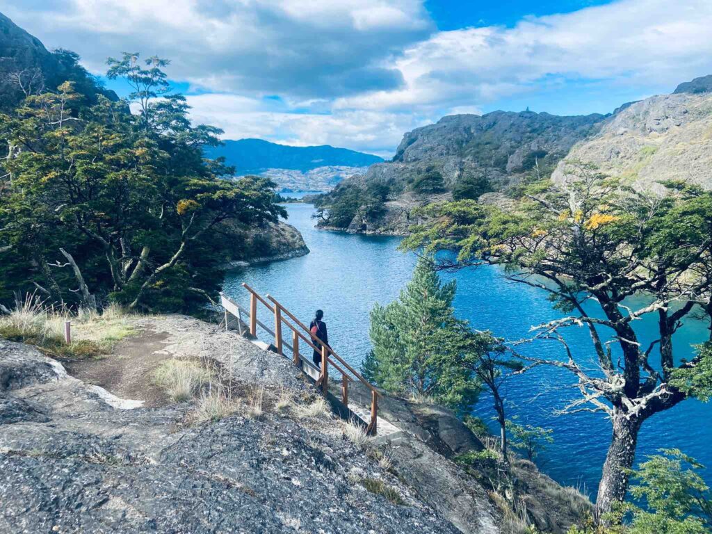
Patagonia National Park: Lagunas Atlas Loop Trail
📍Patagonia National Park
The Lagunas Atlas loop trail is one of the most popular day hikes in this part of Patagonia, yet you’ll never find it crowded. That’s the beauty of Patagonia – and it’s particularly beautiful when dressed in autumnal colours.
It is situated in the Chacabuco Valley and Jeinimeni sectors, in the recently established Patagonia National Park. The route is long, with a steep uphill section and not much shade, so bring a hat and sunscreen. Since it’s an extended trail without any possibility to camp along, start as early as possible.
Note that the trailhead at Los West Winds campsite is only accessible by car; so you’ll need to either rent one or arrange a taxi.
Entrance to the park: | 9000 CLP |
| Trail length: | 20.6 km / 13 mi |
| Difficulty: | Difficult |
| Nearest town: | Cochrane |
| Link to trail: | Alltrails |
| Link to park website: | Patagonia National Park CONAF official website |
Los Carpinteros trail
📍Patagonia National Park
This sweet-and-easy linear hike is a good introduction to the postcard-perfect Patagonia National Park’s Tamango sector, which can be accessed on foot right from Cochrane town. It explores a good mix of flat, foresty, and hilly landscapes, all along the Cochrane River.
Despite not being challenging, this trail is rather unknown. So it’s perfect to enjoy the serenity of the typical Patagonian nature. The short trail ends at Cochrane Lake. In order to make it a full-day hike, you can combine it with other, shorter trails.
If you’re lucky, you might spot a huemul, a deer-like wild animal residing in the park, and Chile’s national animal.
Entrance to the park: | 9000 CLP |
| Trail length: | 9.5 km / 6 mi |
| Difficulty: | Easy/Moderate |
| Nearest town: | Cochrane |
| Link to trail: | Alltrails |
| Link to park website: | Patagonia National Park CONAF official website |
Patagonia National Park is the result of a significant conservation initiative led by the Tompkins Conservation Foundation. It was established in 2018 for the preservation of vast and ecologically important landscapes, and is made up of three areas: Jeinimeni National Reserve, Chacabuco Valley and Tamango National Reserve.
The park boasts a varied and captivating landscape, encompassing snow-capped peaks, rolling grasslands, dense forests, and pristine rivers. In the Chacabuco Valley, jagged mountain ranges and glaciers create a picturesque setting.
The Northern Patagonian Ice Field also contributes to the park’s glacial features. We find that this park focuses more on nature compared to other national parks in Chilean Patagonia, and it offers several day hikes, from easy to challenging difficulty.
Read more about this enchanted, young, and charismatic national park in our hikers’ guide to Patagonia National Park.

Mirador Base of Las Torres hike
📍Torres del Paine National Park
If I had to guess the most popular day hike in the entire Patagonia, my bet would be on this trail. It crosses a variety of landscapes, ranging from forest to bare rocks, before reaching Patagonia’s most famous view; the iconic 3-finger granite peaks and its lake.
Although the route is uphill all the way, only the last part –climbing up to the mirador– is really strenuous.
You can reach the trailhead with a bus ride from Puerto Natales; we collected all the useful info in our post on how to get to Torres del Paine. Due to the distance from Puerto Natales, many hikers decide to overnight at either Campsite Central or Chileno. Make sure to book far ahead if you decide to do so.
Entrance to the park: | 28,500 CLP |
| Trail length: | 20.1 km / 12.5 mi |
| Difficulty: | Difficult |
| Nearest town: | Puerto Natales |
| Link to trail: | Alltrails |
| Link to park website: | Torres del Paine CONAF official website |
🏅 Our accommodation picks at Torres del Paine, on Booking.com:
- A very special place to stay within Torres del Paine National Park is the Ecocamp Patagonia cabins, rated at 9.1. It’s an eco-dorm style accommodation, with various types of rooms, and included breakfast. It’s a great way to sleep in the park, but not in a tent!
- A stylish hotel rated at 8.9, with amazing views over the Lago Grey and Torres del Paine. It has a restaurant and a bar, and offers activities around.
- If you like mountain huts, we recommend this refugio rated at 8.6, with beautiful mountain views, great breakfast and house rules.

Hike to the Glacier Grey Lookout
📍Torres del Paine National Park
The National Park’s #2 site is one of the most impressive glaciers a traveller can observe on a Patagonia trip. This linear trail leads through the Magellanic deciduous forest that covers the slope of Cerro Paine Grande. On the other side, Lake Grey will accompany you all along until the Grey Glacier viewpoint.
The route starts at Campsite Paine Grande, where most hikers overnight (a reservation far ahead is necessary); but it’s technically a one-day hike.
Entrance to the park: | 28,500 CLP |
| Trail length: | 22.2 km / 13.8 mi |
| Difficulty: | Moderate |
| Nearest town: | Puerto Natales |
| Link to trail: | Alltrails |
| Link to park website: | Torres del Paine CONAF official website |
Torres del Paine National Park is a UNESCO-listed protected area in the southern part of Chilean Patagonia. It’s named after its three distinctive granite peaks, the “Towers of Paine“, which reach up to 2,500 meters (8,200 feet). Its expansive glaciers and diverse ecosystems attract yearly thousands of hikers and nature lovers from around the globe.
Hiking is most popular in the summer season (Dec-Feb). In winter, only a few trails are accessible through an organized winter hiking expedition. The park offers two multi-day hikes of different lengths (W trek and O circuit) and various day hikes, often starting from campsites within the park. Entrance to the park and especially campsite bookings have to be made months before the trip. Read here everything about the campsites in Torres del Paine.
For another day hike in Torres del Paine National Park, we recommend the trail to Cuernos Lookouts. It’s less crowded than the Base of Las Torres or Glacier Grey, and just as fascinating.
Always check trail conditions and current entrance prices before setting off, on the linked official park websites. Prices in this post are valid as of January 2024.


