As hikers, Argentina captivates our hearts every single time with its colourful palette of landscapes. In order to have a comprehensive image of the country, one must travel to its three corners – and not forget the mountains that form its heart. So from glaciers, down snowy mountains and deep into evergreen forests and stupendous rock formations, let’s go trekking in Argentina through these 11 stunning hikes.
This article about Argentina hikes contains affiliate links. We’re not selling anything ourselves – we just help products and services we find great. If you click one of them and decide to purchase, it’ll be at no extra cost to you; and we’ll get a trifle that’ll help us bring you more awesome travel guides.
Perito Moreno Glacier Trek

The gigantic Perito Moreno glacier is a wonderful field of snow covering parts of Los Glaciares National Park, Southern Patagonia. We’re talking ice here, large expanses of frozen water caressing the feet of the Andes mountains, in the rugged remoteness of the Deep South. The stuff that adventure is made of.
In order to prevent overcrowding, it’s not possible to roam the glacier on your own, and only one company offers tours. You’ll have two options though: a short, rather accessible hike for a beginner’s look-see; and the Big Ice excursion, which is a longer, more strenuous trek across the glacier.
Even though it’s one of the country’s pricier activities, it’s a unique and unforgettable experience that’s worth every peso; among the best day hikes in Argentina, in our opinion. Both treks end with a short cruise across the water and a glass of whiskey over glacial ice, the perfect ending to a thrilling adventure.
Unsurprisingly, the Perito Moreno is on our list of best treks in South America.
| Distance (time): | two options (2-7 hours) |
| Difficulty: | easy to difficult ★★★★☆ |
| Closest town: | El Calafate |
| Best time to go: | September–June |
| Self-guided option? | No, so book a tour on Viator: Minitrekking or Big Ice |
‘Laguna de los Tres’ Hike
There are so many trekking options in this part of Argentina. So many trails to follow and peaks to ascend, you’d want to set camp at a mountain refuge and never leave again.
The Laguna de los Tres hike is also in Parque Nacional Los Glaciares. It’s the most famous among all of Patagonia Argentina trails, as it allows a close glimpse at the majestic Mount Fitz Roy. The trail starts directly from the town of El Chaltén and ascends straight-ish to the lake.
On the way, an unforgettable landscape of ñire trees, streams and hanging glaciers, and several panoramic views that are sure to leave you as breathless as the hike itself.
This 8-hour out-and-back hike at low altitude can be done as a one day trip. Alternatively, there’s a campsite near the lake, so you can make the most of several trails departing from there, e.g. to Laguna Torre / Cerro Torre, or to Laguna Capri.
Keep planning: All our tips to budget travel in Argentina
➔ Follow this trail on Wikiloc.
| Distance (time): | 22 km / 13.7 mi out and back (8 hours) |
| Difficulty: | moderate ★★★☆☆ |
| Closest town: | El Chaltén |
| Best time to go: | October–November or March–April |
| Self-guided option? | Yes, or on book a tour on Viator |
For a longer and more challenging trek in Los Glaciares National Park, check out the Huemul Circuit. It’s less popular and more demanding, due to more severe weather conditions (including winds up to 100 km/h), and the considerable must-have safety equipment needed (even ziplining equipment) to attempt this hike.
Only experienced mountaineers should consider this 4-day-long trek. Nevertheless, it’s a beautiful route starting at the edge of El Chaltén, offering views of the Southern Patagonian ice field. If you feel up to the challenge, here’s the Wikiloc link to the trail.
Hike to Cerro Guanaco

Parque Nacional Tierra del Fuego is a wild and remote fantasy of forests, bogs, and extensive tundra. Simply the southernmost national park in the world. True enough, it costs either an arm and a leg, or several long days of travel, to get to this part of the world. But the unspoilt scenery and the sensation of reaching the end of the world that you’ll get there is worth every effort.
As expected, there are several trekking options in this extensive (630 square km / 243 square mi) park. Senda Hito XXIV is a 3-km (1.8-mile) hike to the Chilean border, and the Senda Costera follows the shoreline on 8 km (4.9 mile).
But the most popular one has to be the trail that leads up to Mount Guanaco. You’ll start along the coast of Lago Roca, before enjoying a panoramic view of it from the 970m (3182ft) summit. Note that some parts are rather steep, and also muddy; so waterproof shoes with a good grip are a must.
Do you already know our selection of the best National Parks in Argentina?
➔ Follow this trail on Wikiloc.
| Distance (time): | 12 km / 7.5 mi out and back (7 hours) |
| Difficulty: | moderate to hard ★★★★☆ |
| Closest town: | Ushuaia |
| Best time to go: | October–March |
| Self-guided option? | Definitely |
For a short hike closer to Ushuaia, hit the trail that goes up to Martial Glacier. Count 7 km (4.3 mi) from downtown to the trailhead, and 6 km (3.7 mi) more to reach the glacier. After a short ascent through a forest, you’ll be rewarded with gorgeous views upon the Beagle Channel.
The whole way out and back should take just a handful of hours, so you can make it back in time for a hot chocolate. Note that the trail can get busy in the early afternoon, and that it becomes steep and slippery towards the top. Because we love you, here’s the Wikiloc link to the trail.
Refugio Frey Hike and Nahuel Huapi Traverse

Although the town of El Chaltén is nicknamed the ‘trekking capital of Argentina’, we would argue Bariloche is a good competitor to that title. The Northern gateway to Argentine Patagonia is indeed a real paradise for trekkers of all levels, with extensive National Parks protecting snowy peaks, centuries-old forests and crystal-clear lakes.
The popular, well-marked trail to the Frey Refuge serpents through an astonishing array of landscapes. You’ll be going from forest to tundra and to rocky slopes in a matter of hours. Let your curiosity lead you briefly astray, up boulders to rewarding viewpoints and onto secondary trails to secluded lake beaches.
At the end of the day, you overnight in the refuge (or camp outside) and simply come back the same way. You can check the capacity and book your place on the official website (in Spanish).
If you have time to really immerse yourself in this amazing landscape, consider tackling the Nahuel Huapi Traverse. This 5-day hut-to-hut trek crosses the most beautiful points within the National Park, and runs partially along other trails, starting with the one to Refugio Frey.
Check out other stunning hikes for all levels around Bariloche
➔ Follow this trail on Wikiloc.
| Distance (time): | 22 km / 13.6 mi (2 days) |
| Difficulty: | moderate ★★★☆☆ |
| Closest town: | Bariloche |
| Best time to go: | October–April |
| Self-guided option? | Yes, easily |
Paso de las Nubes
This 2-day trek is an ode to the clouds that surround Cerro Tronador. This impressive triple-peaked mountain at the border with Chile dominates the area, covered in snow and glaciers all year round.
The pass connects the Lake District of Argentina to Chile, and although it’s possible to go trekking all the way, this particular hike stops at Lago Frías. It travels across rivers, through meadows and forests of lenga trees, before arriving on the shore of a clear lake.
Not particularly challenging but rather long, it’s important to bring enough food and water with you. Due to forest fire regulations, camping is allowed in two places: at Pampa Linda and in the Agostino Rocca refuge.
Since this isn’t a loop trail, you’ll have to walk back the same way. Alternatively, you can hop on a boat that links the end of the trail at Puerto Frías to nearby Puerto Blest, and then to Puerto Pañuelo, close to Bariloche.
Staying in the area? Check out more multi-day hikes in Patagonia.
➔ Follow this trail on Wikiloc.
| Distance (time): | 23 km / 14.3 mi (2 days) |
| Difficulty: | moderate ★★★☆☆ |
| Closest town: | Bariloche |
| Best time to go: | November–April |
| Self-guided option? | Yes, or book a tour in Bariloche |
For one more day’s worth of trekking, add on a detour to the magnificent Castaño Overo Glacier. Along with the Glaciar Frías, it’s probably the most beautiful glacier in the whole Lake District; with the added value of attracting fewer visitors than their southern cousins.
Branching off from Paso de las Nubes, this trail offers several vantage points on good old Mount Tronador. If you’re interested, here’s the Wikiloc trail to this detour from Pampa Linda. Some tour operators also propose guided group hikes across the glacier, but they require more mountaineering experience.
Sierra de Córdoba

Far from the snowy peaks of the South, the centre-north of Argentina offers few noteworthy trekking options. Yet the mountains close to Córdoba are worth mentioning for their pleasant symphony of green curves and gentle rivers. Along with the nightlife, they might be the only reason to pay the city a visit.
The main advantage of the ‘Sierra de Córdoba’ is its short distance from town, and its easy access by public bus. A mere 50-min drive brings you to the town of Villa Carlos Paz, and you can start filling your lungs, away from the urban hustle and bustle.
There are several trails in the Sierra, but we particularly enjoyed the one that follows the river to Playa de los Hippies. It starts at “Cuesta Blanca” and quickly leaves the pueblo to enter a low-vegetation area. The river beach itself attracts few visitors and a handful of cows, and offers a cosy swim.
➔ Follow this trail on Wikiloc.
| Distance (time): | 2.5 km / 1.5 mi (40 min) |
| Difficulty: | easy ★☆☆☆☆ |
| Closest town: | Córdoba |
| Best time to go: | All year round |
| Self-guided option? | Probably only self-guided hikes here |
Córdoba is a good pitstop on a plane-less Argentina itinerary
Mount Aconcagua day treks

The charismatic Mount Aconcagua is the highest mountain on the continent. In fact, it’s the highest peak outside of the Himalayas, and it takes 2 weeks and a lot of preparation to climb its summit. So that’s that. But if you’re not a mountaineer, there are 2 possible day hikes in the Aconcagua Provincial Park.
The first one is a mere 1-hour flat loop among small lakes, until reaching a beautiful view on all the nearby peaks. Several boards teach about the geology and rock formation in the park. Honestly, considering the entrance fee and the stunning landscape, it would be a shame to stop there.
The second hike follows the same route and continues further into a valley of red rocks and low vegetation. It’s a moon-like scenery of unspoiled beauty. Past the Indiana Jones bridge, it goes slightly up, not steeply, and reaches a plateau where the first base camp (Confluencia) lies at 3,300 m / 10,826 ft. The whole way out and back takes about 4 hours.
Get more info about these Aconcagua Provincial Park hikes.
➔ Follow this trail on Wikiloc.
| Distance (time): | 14.5 km / 9 mi out and back (4 hours) |
| Difficulty: | easy ★☆☆☆☆ |
| Closest town: | Mendoza |
| Best time to go: | November–March |
| Self-guided option? | Yes, or book a tour on Viator |
Ready to conquer the summit? Book a climbing tour on Viator and go you!
Cascadas del Río Colorado (Colorado River waterfalls)
This gorgeous trail proves that it’s worth going hiking in Northern Argentina too. It wanders through a desert-like landscape of red rocks, and hops from waterfall to waterfall – seven altogether. The final fall is a 20-m / 65.6-ft beauty nicknamed the ‘Bride’s Veil’, where it’s possible to take a reinvigorating swim.
You won’t make it there easy-peasy though. Although the landscape is absolutely exhilarating, this trek is considered difficult by most standards. Sure, it’s entirely possible to do the whole trek without a guide. But bear in mind there are several river crossings, some rock scrambling and multiple confusing bypaths.
So if you’re not particularly experienced, it might be best to hire a guide. It’s also a nice way to support the local community and learn about the nature. If you go for that option, make sure you settle on a total price beforehand for either the halfway hike to the 3rd fall, or the whole trek.
➔ Follow this trail on Wikiloc.
| Distance (time): | 11 km / 6.8 mi out and back (4-6 hours) |
| Difficulty: | difficult ★★★★☆ |
| Closest town: | Cafayate |
| Best time to go: | All year round |
| Self-guided option? | Yes, or hire a guide at the entrance |
Cerro Hornocal: Quebrada de Humahuaca

A product of mineral deposits, Cerro Hornocal is known as the 14-colour mountain. It’s the highlight of a fascinating landscape made of desert plateaus, deep canyons and boisterous rivers; and of course a wonderful array of rainbow-coloured mountains that look like they’ve been folded by the Inca gods. Look, the area is so unique and beautiful that it’s listed as a UNESCO World Heritage site since 2003.
Although Mount Hornocal can be seen on its own with a short ride from the village of Humahuaca, it’s also part of a 6-day hike from the Quebrada de Humahuaca to the Calilegua National Park. A splendid occasion to get deep in the land of guanacos, dizzying heights and coca-chewing Andean faces.
In Northwest Argentina, tourism isn’t developed yet, so you can expect an almost solitary experience; and very few fellow hikers, if any. Note that most of the mountain range sits above the 4,000-m mark in altitude, so it’s important to acclimatise beforehand.
Read our hitchhiking adventure in the Northwest of Argentina!
➔ Follow this trail on Wikiloc.
| Distance (time): | Various lengths (1-6 days) |
| Difficulty: | easy to moderate ★★☆☆☆ |
| Closest town: | Jujuy |
| Best time to go: | May–August |
| Self-guided option? | Yes, or book a tour on Viator |
Parque Provincial Teyú Cuaré
You’ve certainly been attracted to San Ignacio by the ruins of the Jesuit mission. We’re with you on that one, the site has a magical aura that’s hard to resist. Well, at the town’s doorstep lies the lush vegetation of the Teyú Cuaré Provincial Park, bordering the mythical River Paraná.
Several paths criss-cross this small park, whose Guaraní name means “lizard’s cave” (we always love a bit of etymology). They dive deep in the thick forest, giving a strong feeling of what it would have been like for the explorers of old. You’ll often end up upon an old ruin, a charismatic viewpoint or a river beach.
One popular trail links to what is said to be the home of a Nazi officer who hid in Argentina after the war. Whoever the owner really was, it’s slightly uncanny to find European luxuries and Fascist relics in the middle of the jungle.
➔ Follow this trail on Wikiloc.
| Distance (time): | 2 km / 1.2 mi one way (30–40 min) |
| Difficulty: | easy ★☆☆☆☆ |
| Closest town: | San Ignacio |
| Best time to go: | All year round |
| Self-guided option? | Yes, or book a tour on Viator |
Iguazú National Park trails
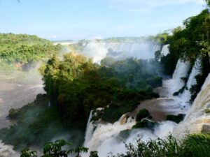
What can we tell you about the Iguazú Falls that you haven’t read anywhere yet? They’re huge, yes. In fact, the largest waterfall complex in the world. You can see them from either Brazil or Argentina, indeed. But the biggest part belongs to Argentina.
One thing we can tell you: their immensity acts like a magnet on your soul. It will remind you of your real size and position in the universal scheme of things.
The national park offers 4 routes to see the falls:
- Circuito Superior gives a distant view of the upper part of the cataracts, perfect for panorama pictures.
- Circuito Inferior goes through the forest and also gives a distant view, this time from the bottom part.
- La Garganta del Diablo (“The Devil’s Throat”) crosses part of the river to go veeery close, at mere inches of the top of the fall!
- The Macuco trail is slightly aside and reaches a small, separate fall, after an hour hike in the forest.
➔ Follow this trail on Wikiloc.
| Distance (time): | Several distances (full day) |
| Difficulty: | easy ★☆☆☆☆ |
| Closest town: | Puerto Iguazú |
| Best time to go: | April–May or August–September |
| Self-guided option? | Yes, or book a tour or your entrance on Viator |
Keep planning: All you need to know to visit the Iguazú Falls
★
Have you found all the info you need to prepare your Argentina trek?
Tell us in the comments below!


.jpg)